Description
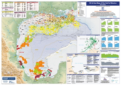
Three years of oil auctions have now set the stage for an exploration drilling boom in Mexico, that should bring billions of dollars of investment into the Mexican Gulf of Mexico. This map compares the United States and Mexican sides of the maritime boundary.
Features
- Oilfields and gasfields
- Oil and gas pipelines (existing, under construction and planned)
- Tanker terminals
- Oil storage facilities
- Floating Production Storage Offloading (FPSO) and Floating Storage Offloading (FSO) vessels
- Mexico awarded license areas (Round 1, 2 and 3)
- US offshore active leases
- PEMEX offshore crude processing in Sonda de Campeche
- Cotemar locations in Mexico and the United States
- Regional oil and gas statistics
- Proved reserves, production and consumption
- United States and Mexico Rig Counts for Gulf of Mexico
- Details for Mexico awarded license areas (Round 1, 2 and 3)
- Cotemar offshore infrastructure
This 2018 edition of The Gulf of Mexico oil and gas map features key infrastructure and developments in the offshore waters of both Mexico and the United States; and also encompasses the latest statistics derived from BP Statistical Review ensuring the data tables of key statistics are accurate and up to date.
Mapping content:
Provides extra details on the infrastructure dense regions of:
Tables and graphics showing:
