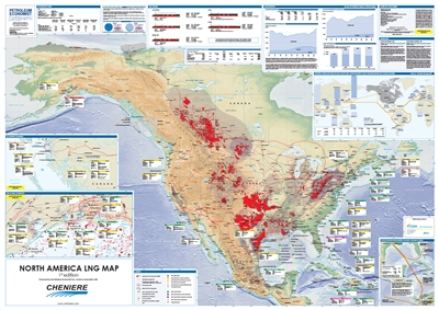
Description
Comprehensive data, charts and illustrations are used within the map to give authoritative analysis of trends in the region's LNG industry.
Features
- Mapping:
- Digital terrain model base map of the North America
- Gas pipelines, including those planned, proposed and under construction
- Major gas producing areas/fields
- Oil & gas basins
- Selected oil & gas plays
- LNG import terminals by status [existing, under construction, planned & proposed and speculative]
- LNG export plants by status [existing, under construction, planned & proposed and speculative]
- British Columbia [Canada]
- Gulf of Mexico [US]
- Export routes from Sabine Pass
- World shipping distances from US Gulf coast and Canadian West coast
- Gas statistics including regional gas reserves, gas production and gas consumption
- North America regional outlook to 2035
- North America LNG capacity forecast 2020
- North America trade movements of LNG
- Conversion tables
- LNG vessel types
