Description
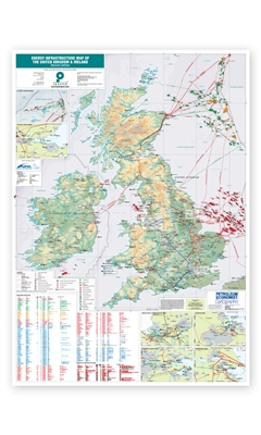
Comprehensive data, charts and illustrations are used within the map to give authoritative analysis of trends in the region's energy infrastructure.
Features
- Mapping content:
- Onshore and offshore pipelines (crude, gas, condensate, oil products, oxygen/gas products, ethylene and government/OPA), including existing, under construction and planned or proposed
- Gas processing facilities
- Underground gas storage
- LNG import terminals
- LNG storage and
- Gas compressor stations
- Crude oil import/export terminals,
- Independent oil storage terminals,
- Oil refineries,
- Coal, oil, nuclear, hydro, and CCGT power stations and
- Chemical works
- Major pipelines, with detail on route, length, diameter, product, operator and commission date
- Grangemouth,
- Humberside,
- Stanlow,
- St Fergus,
- Teesside and
- Atlantic Margin
